


South Rushville Precinct, Sheridan County, Nebraska
About
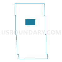
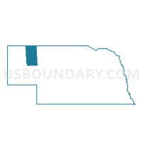
Outline

Summary
| Unique Area Identifier | 613947 |
| Name | South Rushville Precinct |
| County | Sheridan County |
| State | Nebraska |
| Area (square miles) | 84.09 |
| Land Area (square miles) | 84.05 |
| Water Area (square miles) | 0.04 |
| % of Land Area | 99.95 |
| % of Water Area | 0.05 |
| Latitude of the Internal Point | 42.66291040 |
| Longtitude of the Internal Point | -102.41249290 |
Maps

Graphs
Select a template below for downloading or customizing gragh for South Rushville Precinct, Sheridan County, Nebraska


Neighbors
Neighoring Voting District (by Name) Neighboring Voting District on the Map
- Hay Springs Precinct, Sheridan County, NE
- North Rushville Precinct, Sheridan County, NE
- South Sheridan Precinct, Sheridan County, NE
- West Gordon Precinct, Sheridan County, NE
Top 10 Neighboring County Subdivision (by Population) Neighboring County Subdivision on the Map
- Hay Springs precinct, Sheridan County, NE (951)
- Rushville city, Sheridan County, NE (890)
- South Sheridan precinct, Sheridan County, NE (546)
- North Rushville precinct, Sheridan County, NE (445)
- West Gordon precinct, Sheridan County, NE (199)
- South Rushville precinct, Sheridan County, NE (124)